

Modeling Tools for Stormwater Management
There is an ever-growing and ever-improving suite of modeling tools available to civil engineers that can be used for design and analysis of stormwater infrastructure. These range from simple, focused tools that streamline basic calculations, to robust models that solve multi-dimensional numerical flow equations. Some tools provide either hydrologic or hydraulic calculations separately, or both together, while other tools offer water quality analysis capabilities. Some modeling tools are most applicable to natural channels and rivers while others excel for pipe systems in the urban environment. Some modeling tools have become the standard for certain industries or applications, such as the use of HEC-RAS for FEMA compliance or Bentley Geopak Drainage/ORD for transportation projects. Many engineers may find that they use multiple modeling tools on any given project.
Advances in Recent Years
There have been game-changing advances in modeling technology over the past 10 to 15 years, such as increases in computing power and the development and application of multi-dimensional flow models. Modeling frameworks such as HEC-RAS, PCSWMM, InfoWorks ICM, SRH-2D, FLO-2D, and others have incorporated 2-dimensional (2D), depth-averaged modeling algorithms that allow engineers to simulate and evaluate complex flow regimes while reducing the number of simplifying assumptions required for 1-dimensional (1D) models. Many of these modeling frameworks use a combination of 1D and 2D algorithms for simulation and interaction of flow through the various stormwater components. For example, flow may be simulated as 1D through a pipe culvert, with inlets and outlets connected to a 2D mesh.
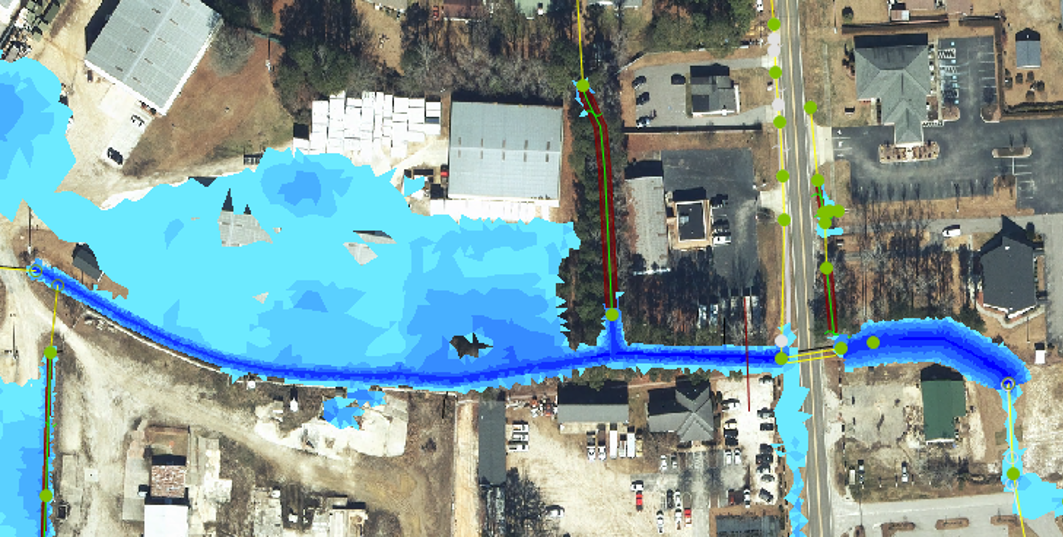

Images from InfoWorks ICM 1D/2D model in Fayetteville, North Carolina.
While the 1D/2D modeling approach has been very useful for most stormwater and floodplain modeling projects, when better understanding of localized hydraulics is desired (such as for dam spillways or other large, high-risk hydraulic structures), 3-dimensional (3D) Computational Fluid Dynamics (CFD) models like FLOW-3D are also available to the engineer. 3D models solve the governing equations for fluid flow in 3 dimensions (i.e. Navier-Stokes equations) and are best suited for complex flow regimes where depth-averaged 2D models will not adequately simulate flow depths and velocities. As expected, these 3D models generally require more expertise, effort and computational power to implement.
The available modeling tools are continually being improved for stability of 1D/2D connections, for 2D mesh generation, and for data management and processing. One recent advancement has been the incorporation of “rain-on-grid” or “direct rainfall” capabilities, where the rainfall-runoff process is simulated by directly applying rainfall to a 2D mesh representing the terrain. While not being widely used by practitioners, this method can further improve results, reduce assumptions, and reduce the effort required to delineate and develop watershed characteristics.
While the use of 2D and 3D models have allowed us to simulate more complex flow regimes and increase our confidence in the resilience of stormwater infrastructure design, these models can be data intensive and require more computational power compared to previous 1D flow models. This challenge has been met with the use of cloud computing, which greatly increases computational speed, number of concurrent computational runs, and can facilitate collaborative modeling efforts.
The Future is Bright
Advances in modeling technology are expected to continue. While cloud computing is not yet widely used by everyone, it may become a mainstay in the future, especially as input data become more precise and computational demands increase. In addition, new Artificial Intelligence (AI) and machine learning tools are under development that could streamline modeling setup and post processing. “Geo AI” tools are being developed to facilitate processing of geospatial information for model input, including segmentation and detection, and language learning tools that can assist with coding for model setup and post processing of results. With the pace of advancement in recent years, it’s not hard to imagine an AI modeling “assistant” that would work collaboratively with the engineer to set up, trouble shoot, calibrate, and post process models. It’s certainly an exciting time to be an engineer in this field and to participate and benefit from these continued advances in technology.
Team Gradient’s Favorite Tools
There are currently too many modeling tools available to the engineer to efficiently list and discuss on this web blog. The following table lists modeling tools that we here at Gradient have experience with and/or have found to be useful for our projects. The table includes columns with distinguishing characteristics. Please don’t hesitate to reach out with any questions or if you would like to discuss these or other modeling tools for application on your projects.
| Modeling Tool | Hydrology | Hydraulics | Water Quality | 1D-2D Hydraulics | Scour Evaluation | GSI/LID Evaluation | Public Domain | Learning Curve |
| HEC-HMS | X | X | Medium | |||||
| HEC-RAS | X | X | X | X | X | High | ||
| PCSWMM | X | X | X | X | X | High | ||
| InfoWorks ICM | X | X | X | High | ||||
| SRH-2D/SMS | X | X | X | X | X | High | ||
| WinSLAMM | X | X | X | Medium | ||||
| Bentley Geopak Drainage/ORD | X | X | High | |||||
| HydroCAD | X | X | X | Low | ||||
| FHWA HY-8 | X | X | Low | |||||
| FHWA Hydraulic Toolbox | X | X | X | Low |
 About Alex,
 About Alex,
Director of Water Resources
Alex Nice, a licensed Professional Engineer and LEED Accredited Professional, brings 30+ years of experience in civil infrastructure, serving municipal, transportation, and industrial sectors. He specializes in planning, design, permitting, inspection, and maintenance of infrastructure systems. With deep expertise in H&H modeling and watershed management, Alex supports both new developments and existing system upgrades to ensure regulatory compliance and performance optimization.
![]()